Gwytherin Churchyard, Denbighshire

Stone Row: OS Grid Reference – SH 8767 6147

Also known as:

  1. Gwytherin Church Standing Stones
  2. The Four Stones

Getting Here

From the Denbigh road (A543 and A544) turn off at Llansannan for Gwytherin on the B5384 for 6 miles or so. At the village of Gwytherin St Winifred’s church stands roughly in the middle of the place at a junction of four roads. The church stands upon a small round hill and within the confines of the churchyard (north side) are four small standing stones – you can’t really miss them!

Archaeology & History

At the northern side of the churchyard near the wall there’s an alignment of four small standing stones probably dating from the Bronze Age.  The stones stand roughly 3 metres or 6 feet apart and are about 1 metre or 3 feet in height.  The westernmost stone has a Latin inscription carved onto it which is ‘VINNEMAGLI FILI SENEMAGLI’, or, ‘The Stone of Vinnemaglus, son of Senemaglus’, which is generally thought to date from the Romano-British period in the 5th-6th century AD and to be a grave marker.  Most probably the inscription was carved onto the prehistoric stone during the early Christian period — the stones themselves being from pre-Christian times.

The general thinking is that these stones belonged to a Bronze Age settlement that stood here long before any church was founded.  Perhaps there were other stones here forming a linear alignment that must have meant something to the ancient folks who lived here.  There has also been speculation as to whether the inscribed standing stone could actually mark the grave of St Winifred herself.

The churchyard is circular, indicating that it is a pagan sacred site.  Celtic churches being built on sites like this to Christianize them, but not entirely forget the meaning to the peoples of “the old religion,” as it’s called.  Also in the churchyard stand three ancient yew trees — yet another sign that the site is a holy one.

The first church in Gwytherin was founded by St Eleri (Elerius), a Welsh prince, in the mid-7th century.  He may be identical with St Hilary, a saint commemorated at a village of that name near Cowbridge, South Glamorgan.  Other than that, Eleri and his mother, Theonia, founded a double monastery here: one for men and the other for women, to which a young St Winifred (of Holywell) came to and was elected second abbess after Theonia.  St Eleri was probably a disciple of St Beuno, uncle to St Winifred, and also her cousin.  Here in 650 or 670 AD Winifred was buried in the churchyard — her relics being taken to Shrewsbury abbey in 1138.

References:

  1. Burl, Aubrey, From Carnac to Callanish, Yale University Press 1993.
  2. Houlder, Christopher, Wales: An Archaeological Guide, Faber & Faber: London 1978.
  3. Hulse, T.G., Gwytherin: A Welsh Cult Site Of The Mid-Twelth Century, (unpublished paper) 1994.
  4. Nash-Williams, V.E., The Early Christian Monuments of Wales, Cardiff, 1950.
  5. Westwood, J.O., “Early Inscribed Stones of Wales,” in Archaeologia Cambrensis, 18:255-259, 1863.

Copyright © Ray Spencer 2011


St Winefride’s Well, Holywell, Flintshire.

Holy Well:  OS Grid ReferenceSJ 1851 7627

Also Known as:

  1. Ffynnon Gwenfrewi
  2. St. Winifred’s Well

Getting Here

St.Winifred’s Well

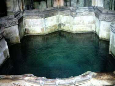
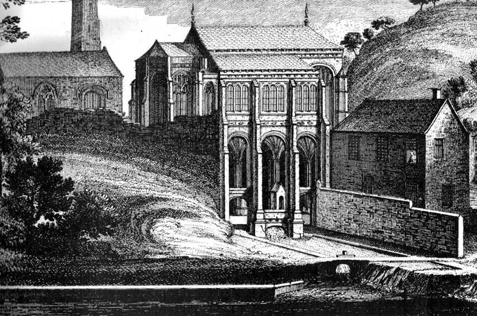
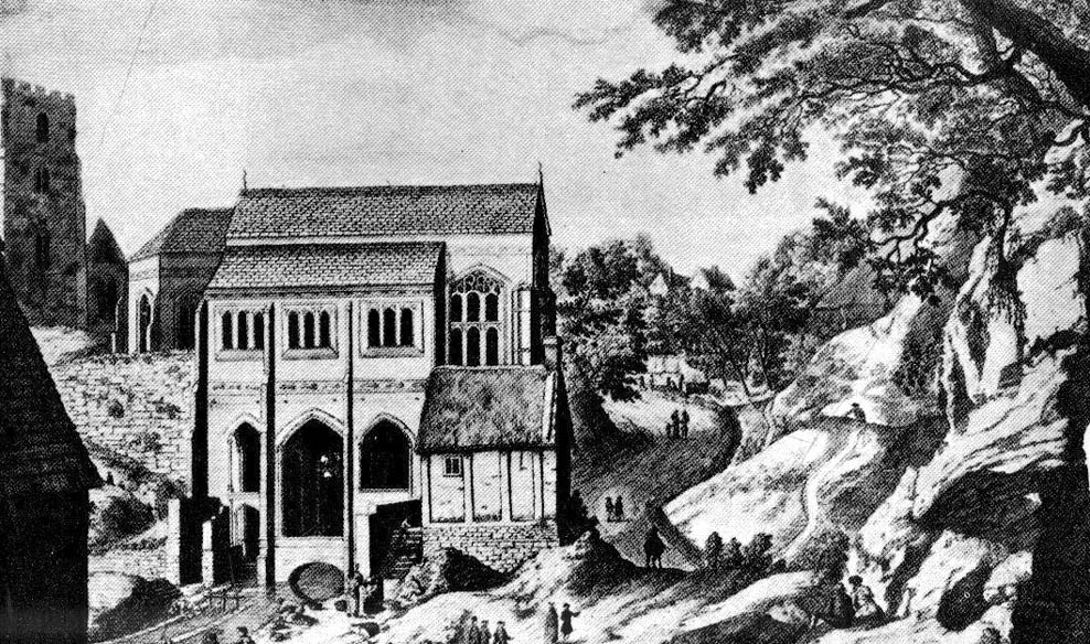
From the Chester ring road head into north Wales along the coast road (A548) from Connah’s Quay for about 13 miles taking you through Flint. After 12 miles turn left into Holywell town (Treffynnon). At the western end of the town go down the Greenfield-Mostyn road back towards the A584 taking you down a hill.  After 500 hundred yards you arrive at the holy well/shrine and pilgrimage centre on the right-hand side; there is parking on the opposite side of the road. There is a small entrance fee, but as well as the famous healing well and bathing pool, they have a gift shop, toilet facilities and a late medieval/Gothic two-storey structure that is built over the polygonal, vaulted well chamber, whilst at the side (at the corner of the hill) stands another Gothic chapel from 1500.

History and Legend                                                                                                 

According to the well known legend, a young Welsh girl called Winefride or Gwenfrewi, was the daughter of patrician parents, Thenith (Thewyth) and Gwenlo, who lived at Bryn-y-Castell (Treffynnon) at the beginning of the 7th century AD.  She was a very religious girl who was known for her kindness and charities to people in the area that was then called Tegeingl (after the Decengle tribe).  Winefride grew up to be a very beautiful young woman which troubled her because she had no wish to marry, only to live a life of chastity and serve God as only she knew how.

St. Winefrides Well 1742

One day a local chieftain from Hawarden (Penarlag) called Caradoc ap Alyn came hunting in the area. He became very thirsty so stopped off at the house where Winefride lived with her parents.  However, on this particular day her parents were attending the local church where St Beuno, her uncle, was conducting a service.  Prince Caradoc soon began to seduce her so she ran to the church but with the prince in hot pursuit.  When he caught up with poor Winefride, she again resisted him so he took his sword and beheaded her.  Her severed head fell to the ground and rolled down a hill and where it came to rest a spring of water gushed forth from the ground.  Her parents and uncle came rushing out of the church at which point St Beuno cursed the evil prince, who was calmly wiping blood from his sword, causing him to sink into the ground — never to be seen again.  St. Beuno then placed the severed head back into place, restoring Winifred to life again but leaving her with a thin scar round her neck.

Later, Winifred was entrusted for her education to St Beuno whom sent her to various holy men including St. Elerius at Gwytherin near Llanwrst.  Here she became abbess of a convent that had been founded by Elerius, with his mother St. Theonia as first abbess; and it was here for the next 40 years that Winifred lived out her life.  She was said to have died at Gwytherin in either 65o or 670 AD.  Her body was first interred in the churchyard there, however in 1138 her relics were transferred to Shrewsbury Abbey.  Sadly however, her shrine there was destroyed in the 16th century and now only a few relics remain with a finger-bone being housed at a convent in Holywell.

Mythology and Folklore                                                          

St. Winefrides Well 1750

The holy well and shrine of St. Winifred at Holywell became a place of pilgrimage during the middle-ages and many miracles of healing were wrought there.  The sick were cured of infirmities of the legs and body; crutches were left at the well and many were cured of leprosy, eye complaints, loss of hearing, being not able to bear a child, mental illness, palsy and lung disorders etc.  During the Reformation the holy well suffered much, but from the 17th century onwards pilgrims were returning to the holy place and, more recently it has become the Welsh Lourdes and still pilgrims come in droves from all over Wales and beyond.  The vaulted Gothic structure covering the well shrine is richly carved with bosses depicting various characters including St Beuno, Earl Stanley, Lady Margaret Beaufort, biblical characters, animals and an abbot of Basingwerk abbey, but there is also much recent graffiti too.  A tall statue of St Winefride looks down over the well while candles burn all around.  In the larger bathing pool outside, a stone lies at one side — this is claimed to be where St. Beuno sat whilst teaching his young niece.  Red stains on stones at the front of the well-basin were long taken to be the martyr’s bloodstains, but now these are thought to be iron oxide pigmentation on the lichens.  Today the people still come either to bathe in the special pool, throw coins in the well, or fill bottles with holy water from a tap on the wall.  Faith in miracles of healing is still much in evidence here and may it continue to be for many years to come.  Everyone is welcome here, you don’t have to be a Roman Catholic!

References:

  1. UneXplained - LiebreichBord, Janet & Colin, Sacred Waters, Paladin: London 1986.
  2. David, Christopher, Saint Winefride’s Well  – A History and Guide, Gomer Press: Llandysul 2002.
  3. Edwards-Charles, Thomas, Saint Winefride and Her Well – The Historical Background, Holywell 1962.
  4. Heath, Sidney, In the Steps of the Pilgrims, Rich & Cowan: London 1950.
  5. Jones, Francis, The Holy Wells of Wales, University of Wales Press: Cardiff 1992.
  6. Liebreich, Karen, UneXplained: Spine-tingling tales from Real Places in Great Britain and Ireland, Kindle 2012.
  7. Simcock, Richard, North Clwyd At Random, Countryside Publications Ltd: Chorley 1986.
  8. Spencer, Ray, A Guide to the Saints of Wales and the West Country, Llanerch: Felinfach 1991.

Copyright © Ray Spencer 2011


Pillar of Eliseg, Pentrefelin, Llangollen, Denbighshire

Cross:  OS Grid Reference – SJ 20267 44522

Also Known as:

  1. Eliseg’s Pillar

Getting Here

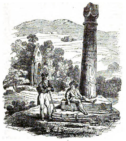
The Eliseg Pillar

From Llangollen, take the A542 north for about three miles up along the famous Vale of Llangollen.  At the ruined abbey of Valley Crucis continue along the same road for another ½-mile whence, at the side of the road in a field and upon a small mound, stands the ancient monument: the Pillar of Eliseg.

Archaeology & History

The sandstone pillar or pillar-shaft stands upon a large square-shaped base stone which sits atop a tumulus — a Bronze Age burial mound (cairn) inside which were found, during excavations in 1803, the remains of a body, perhaps that of a Romano-British or Dark-Ages chieftain (possibly Eliseg?), with what were described as “blue stones” both beneath and on top; the cremated body lying within a stone-slab chamber along with a silver coin.  But the ancient pillar monument itself is much later in date — probably mid-9th century AD, though there has been speculation by some historians that the pillar was actually a tall cross, alas without its head, dating from a couple of centuries earlier, with the inscription being carved onto it sometime between 840-845 AD.  It was erected by Prince Cyngen fab Cadell (Concenn) about the year 844 in memory of his great-grandfather Eliseg or Elise.  Cyngen died in Rome in 854 AD.

Over the centuries the pillar has suffered from the ravages of time.  Its long Latin inscription was originally 31 lines divided into readable paragraphs running horizontally but now only 7 or 8 of these lines are visible.  But fortunately the writer and historian Edward Lhuyd made a drawing of the monument and its inscription back in 1696.  The inscription when translated reads as follows:

1. Concenn son of Cadell, Cadell son of Brochmail, Brochmail son of Eliseg, Eliseg son of Guoillauc

2. Concenn therefore being great-grandfather of Eliseg erected this stone to his great-grandfather Eliseg

3. It is Eliseg who annexed the inheritance of Powys…throughout nine (years) from the power of the English which he made into a sword-land by fire

4. Whosoever shall read this hand-inscribed inscription stone, let him give a blessing on the soul of Eliseg

5. It is Concenn Who…with his hand…to his own kingdom of Powys…and which…the mountain…the monarchy Maximus…of Britain…Concenn, Pascent…Maun, Annan.

6. Britu, moreover, (was) the son of Guorthigirn (Vortigern) Whom (St) Germanus blessed and whom Severa bore to him, the daughter of Maximus the king who slew the king of the Romans and

7. Convarch painted this writing at the command of his king Concenn

8. The blessing of the Lord (be) upon Concenn and all members of his family and upon all the land of Powys Until the day of judgement or doom. Amen.

The upper section of the pillar, which is broken at the top, was re-erected on top of the burial mound in 1779 which probably means that the monument is not in its original place.  The lower section was sadly broken away from the shaft during the English Civil war and has long since disappeared. However, this monument is still quite an impressive site and can be seen from a great distance around.

References:

  1. Bartrum, P.C.,  Early Welsh Genealogical Tracts, Cardiff: UWP, 1966.
  2. Barber, Chris, More Mysterious Wales, Paladin 1987.
  3. Houlder, Christopher, Wales: An Archaeological Guide – the prehistoric, Roman and early medieval field monuments, Faber and Faber, London 1974.
  4. Tyack, George S., The Cross in Ritual, Architecture and Art, William Andrews: London 1900.
  5. Westwood, J.O., Lapidarium Walliæ – The Early Incised and Sculptured Stones of Wales, Oxford University Press 1879.

Copyright © Ray Spencer 2011 


Maen Achwyfan, Whitford, Flintshire

Cross: OS Grid Refence – SJ 129 788

Also Known as:

  1. The Stone of Lamentation
  2. St Cwyfan’s Stone

Getting Here

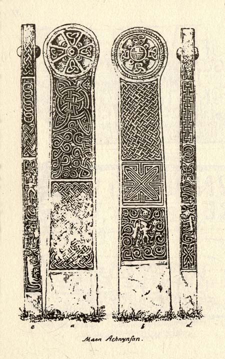
Maen Achwyfan Cross (after J.O. Westwood)

Go north on the A5026 from the town of Holywell for about 3 miles; at the hamlet of Lloc take the turning first right towards Trelogan village for another mile – the ancient cross stands in the corner of a field at the junction of 3 roads at the turning from Whitford to Trelogan, halfway between Whitford and Sarn. The cross can also be reached via Pantasaph from the A55.

History

The cross probably dates from 1000 AD and is said to be the tallest wheel-headed cross in Wales, standing at 11 feet 3′ in height. The metal fence surrounding the cross spoils the monument quite a bit, but it is there for security reasons.  It is richly decorated on all sides and on the cross-head. Much of the decoration is Celtic in origin, but there are also Viking influences here, probably Northumbrian. On the south face there is a human figure standing on a serpent that has associations with the Norse god Odin; also a three-legged horse that may also be connected to Odin. The north-west face has Celtic pattern-work in the form of the letter “X” and below that another figure (naked) holding a spear. The north-east face is rather eroded, but there is some Celtic-style decoration. There is more knotwork and chainwork elsewhere on the cross with other animal figures.  The wheel-head has a distinctive central boss and a four star-shaped cross radiating from the boss.

Folklore and Legend

The cross is also called ‘The Stone of Lamentation’ because penances were carried out at the cross in the Middle Ages. This act would have concluded with weeping and the ‘act of contrition’ by pilgrims visiting the site whilst making their way between St Winifred’s Well and St David’s.  Legend says that St Cwyfan, a local 7th century Celtic saint preached on this site and set-up the cross – hence the name, Maen Achwyfan.  One local legend tells us that Queen Boudica fought her last battle against the Romans close by in the fields called ‘Cydio ar Leni’ or ‘The fields of the seizing legions’.  During the Middle Ages the monks of Basingwerk Abbey preached at the cross and also set up a chapel for pilgrims just to the south at Whitford.

References:

  1. Allen, J. Romilly, “Celtic Crosses of Wales”, in Archaeologia Cambrensis, 1899.
  2. Owen, Rev. Elias, Old Stone Crosses of the Vale of Clwyd and Neighbouring Parishes, Bernard Quaritch: London & Oswestry 1886.
  3. Sharkey, John, Celtic High Crosses of Wales, Carreg Gwalch: Llanrwst 1998.
  4. Westwood, J.O., Lapidarium Walliæ – The Early Incised and Sculptured Stones of Wales, Oxford University Press 1879.

Copyright © Ray Spencer 2011


Eyam Cross, Eyam, Derbyshire

Cross:  OS Grid Reference — SK 2178 7639

Getting Here

The village of Eyam is located some 9 miles south-east of Chapel-en-le-Frith and about the same from Sheffield, which lies to the north-east. Go to the centre of the village and find the church of St Lawrence standing beside the road to Foolow close to Eyam Hall and just west of the B6521 road to Sheffield.  The Saxon cross stands in the churchyard.

History and Folklore

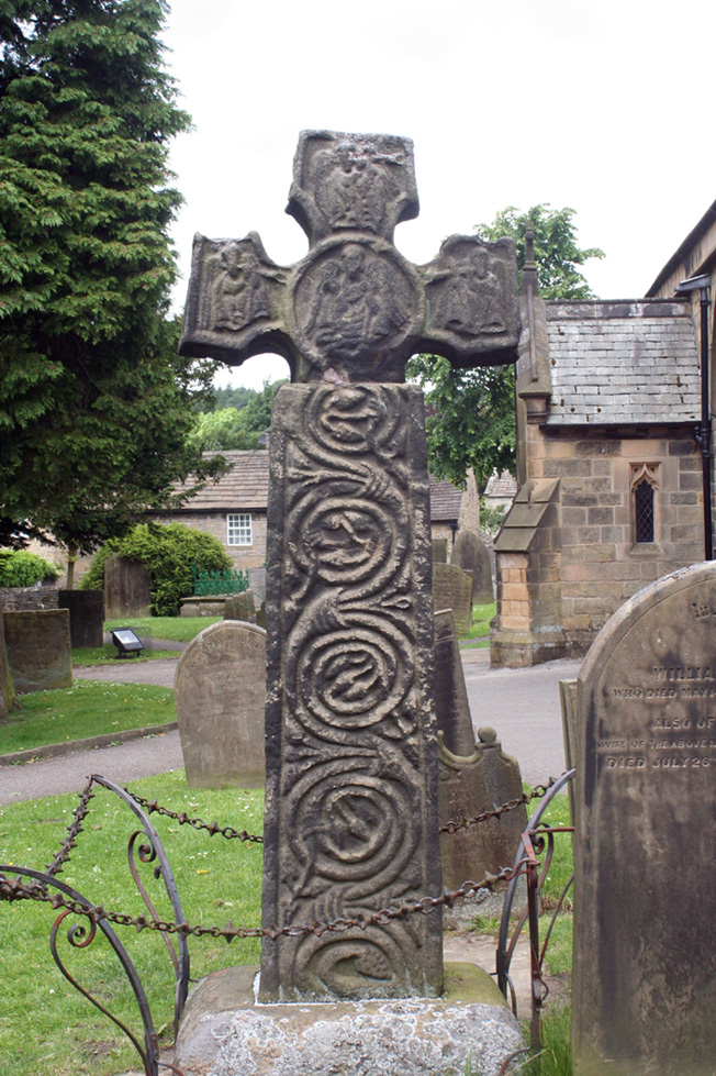
Eyam Cross, east face (from Wikipedia)

This very fine Anglo-Saxon (Mercian) cross stands 8 foot tall and dates from the 8th-9th centuries. It was apparently set up by missionaries from the north at Cross Low on the moors to the west of Eyam. Originally it was a wayside preaching cross that was 10 feet high and certainly must have looked very spectacular, but now it is only 8 feet high due to it being knocked about a bit in more recent times and losing one of its shaft sections. In the 18th century the cross was discovered beside a trackway on the moors, from whence it was brought to the churchyard of St Lawrence’s church;  but then for a long time it stood abandoned and uncared for in the corner of the churchyard. Eventually  it was restored and placed in the churchyard where it now stands proudly.

The cross is said to be the only one of its type in the Midlands that retains its cross-head. It has some very rich decoration on the west face with fabulous interlacing scroll-work running up the shaft that is typically Mercian in origins. On the west-face, especially the upper section, there are human figures probably St Mary the Virgin with the baby Jesus, angels and Christ in glory, each in their own sections or panels. The cross is grade 1 listed.  St Lawrence’s church houses a Saxon font.

References:

  1. Rev. Arthur, C., Illustrated Notes on English Church History, Society for Promoting Christian Knowledge: London 1901.
  2. Rodgers, Frank, Curiosities of Derbyshire and the Peak District, Derbyshire Countryside Ltd 2000.

Copyright ©  Ray Spencer 2011 


Tooter Hill, Bacup, Lancashire

Settlement:  OS Grid ReferenceSD 888 237

Getting Here

From Bacup town centre, take the A681 Sharneyford road for about 1½ miles towards Todmorden.  At Sharneyford village take the footpath south for about 1 mile to Parrock Farm.  At the farm, take the footpath in an easterly direction to Tooter Hill. Upon reaching the hill, head around the southern periphery for about ½-mile, or climb the hill to its height of 430 feet.  Here is the former site of a Neolithic or Bronze-Age settlement. From the top of the hill you get fairly spectacular views of the surrounding countryside.

Archaeology & History

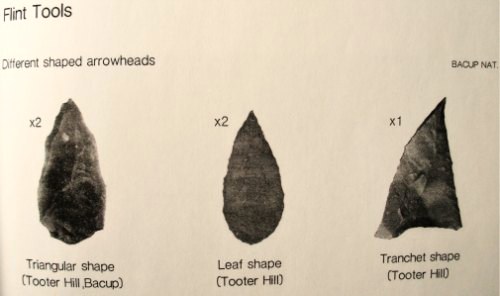
Flints from Tooter Hill

The former (or lost) site of The Tooter Hill prehistoric settlement or enclosure is not marked on any map. It has unfortunately suffered from quarrying on its periphery, but this has long since ceased. There are some small mounds at the southern side of the hill along with traces of earthworks, but I don’t know whether these are part of the former quarry workings.  However, a number of artefacts have been excavated from the peat at this site; these include a tanged and barbed arrowhead with serrated edges — probably from the Neolithic period 4,500BC-2,500BC as well as a Bronze-Age arrow-head 2,500BC-700BC, and also a tranchet-shaped arrow-head of unknown date.  These artefacts are housed in the N.A.T museum in Bacup town centre.  Other finds from Tooter hill on display are some small flint implements such as a flint scraper, flint adze and a flint borer.

References:

  1. Yates, G.C.,  “Stone Implements,” Transactions of the Lancashire & Cheshire Antiquarian Society, 5, 320-331.

Copyright © Ray Spencer 2011


Broadbank Earth Circle, Thursden, Burnley, Lancashire.

Enclosure: OS Grid Reference — SD 9024 3522

Also Known as:

  1. Burwains Enclosure
  2. Burwains Camp

Getting There

From Nelson town centre go north east towards Catlow, turning left near the Shooters Arms public house, then turn right again to the Coldwell Activity Centre.  Carry on towards Thursden Valley till you see the World War 2 pillbox on the right.  Here turn right and after 300 yards a picnic site and carparking area is reached along the Briercliffe road. On the opposite side of the road over a wall and barbed wire is Broadbank Earth Circle, though unfortunately there is not much to see there today. 

Archaeology

First excavated in 1950 by the Archaeology Department of Liverpool University and again in the 1960s, the earthworks here stand at 1,147 feet above sea-level (350m). The site comprises of an earth circle 150 feet (46m) in diameter which encloses an inner ditch 1 foot (30.5cm) deep and 10 inches (25.4cm) across. The bank was composed of boulder clay thrown out from the ditch. A hearth was found below the bank at the eastern end.  Some rough flint and chert flakes were also found together with a stone axe of Langdale origin. This is four-and-half inches or 11.4cm wide.  It has a curved cutting edge and a thin rounded head. Its surface is ground smooth but there is no evidence of polishing.

The earthworks at Broadbank have suffered through farming activity over many centuries and the earthen circle is now difficult to see at ground level, though the inner ditch is still visible. The low hillside or, what look like ramparts, at the northern end by the pillbox are probably not in any way connected, though this low bank may have added to the building of the bank. Archaeologists consider the site to be of Iron Age origin.

References:

  1. Liverpool University Archeology Department, Report and pamphlet, 1950.
  2. Powell, J.G.E., “Excavations of a Circular Enclosure at Broadbank, Briercliffe, Lancs,” in Transactions of the Historical Society of Lancashire & Cheshire, 104, 145-151.

Copyright © Ray Spencer, The Northern Antiquarian 2011


Rudston Monolith, East Yorkshire

Standing Stone:  OS Grid Reference – TA 09803 67740

Getting Here

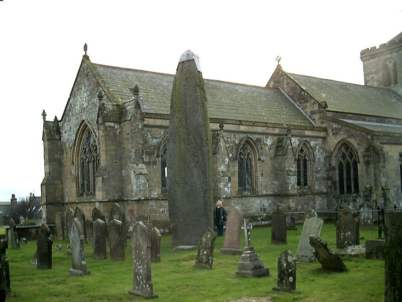
Rudston’s monolith (photo by ‘QDanT’)

To get to the monolith travel along the B1253 road to the west of Bridlington for about 5 miles or from York take the A166 in an easterly direction then onto the B1251 and at Fridaythorpe take the B1253 east again toward Bridlington. The huge stone cannot be missed from the road and from the surrounding area. It stands within the graveyard of All Saints’ church at the north-eastern side of Rudston village.

Archaeology & History

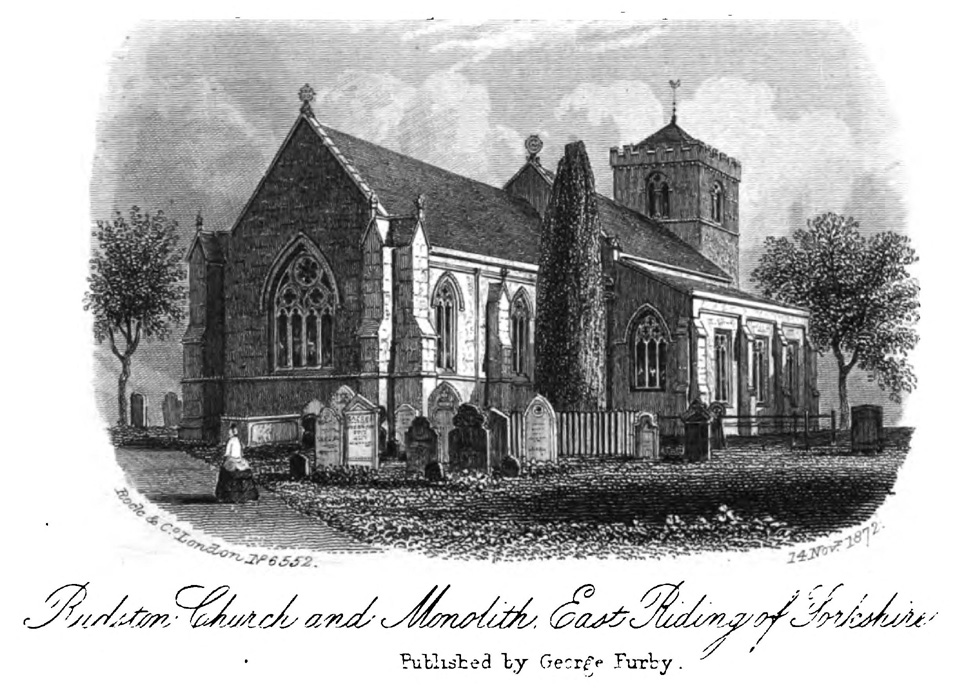
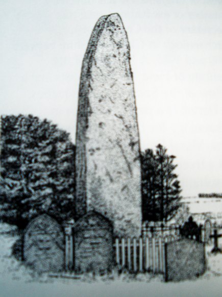
Located in the graveyard of All Saints’ church, this huge and mighty monolith or menhir stands at 25 foot 9 inches high (7.7 metres), and is the tallest prehistoric standing stone in Britain. It is estimated to weigh 40 tons, and it is thought to be the same in height below ground as what it is above the ground, though I don’t know whether anyone has ever checked that theory out. It probably dates from the Bronze-Age about 1,600 BC. Because of vandalism and erosion the top of the stone now has a lead cap, so it is said the stone could have originally been 28 feet high. So where has the top part gone to, I wonder. We are told that the stone was dragged, or rolled on logs, all the way from an outcrop at Cayton Bay some 10 miles as the crow flies to the north.

Royston’s 1873 drawing
Rudson Monolith (Louise Hutchinson 1988)

Rudston monolith stands at the end of at least one cursus monument on an old prehistoric alignment (see the Rudston B Cursus entry).  It would appear to have played an important ingredient in a huge ceremonial landscape on the Gypsey Race.  Also in the churchyard (north-east corner) there is a large slab-stone cist which was removed from a nearby round barrow and also a gritstone. At Breeze Farm about one mile to the south-west of the village is the site of a Roman villa.

Folklore

The folklore elements tell us that this is, in fact, a phallic stone and in pagan times some form of ritual was held around the monolith, but then the Christian church was built around it in the Dark Ages – it was a case of Christianity adopting the pagan religion and allowing the stone to stay where it was, but what else could they do because the stone was to big to move, so a lot of tolerance was in order here. The present church of All Saints’ dates from the Norman period. In any case the stone had stood here for a good 2,000 years or more before any church was established in the village. According to the legend, the devil hurled the huge stone at the first Christian church on the site, but as usual he just missed – doesn’t he always!

References:

  1. Bord, Janet & Colin, Ancient Mysteries of Britain, Diamond Books: London 1991.
  2. Anderton, Bill, Guide To Ancient Britain, Foulsham: London 1991.
  3. Darvill, Timothy, AA Glovebox Guide – Ancient Britain, AA Publishing Division: Basingstoke 1988.
  4. Royston, Peter, Rudston: A Sketch of its History and Antiquities, George Furby: Bridlington 1873.

© Ray Spencer, The Northern Antiquarian 2011