Standing Stone: OS Grid Reference – NM 85952 01568
Also Known as:
- Creagantairbh Beag

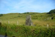
From Kilmartin go north on the A816 Oban road, and after 1½ miles watch out for the small B840 road on your right, to Ford and Loch Awe. Less than a mile along the winding road, just after the track to the farmhouse on your left, keep your eyes peeled for the standing stone on your right, whose top is peeking over the old walling. If you’re not careful you’ll miss it!
Archaeology & History
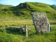
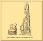
From the roadside this looks like just a reasonably small standing stone, but closer inspection shows it’s been snapped halfway up—apparently in a great storm in December 1879. If you look over the wall, just a couple of yards behind the upright you’ll see the larger section of stone that was attached to the 6-foot upright before its calamitous fall. Originally it was said to have been 16 feet tall!


The first description of the stone is thought to be by the great J. Romilly Allen (1880) in his brief visit to Ford, saying simply that the stone “is close to the road on the east side, 1 mile from Ford. It is 14 feet high and 3 feet by 4 feet at the base. The material is slate. It inclines considerably from the perpendicular”—meaning, that he saw it before the stone had been broken. Lucky bugger!
More than twenty years later David Christison (1904) visited the site and wrote his of his finds in an essay for the Society of Antiquaries, although in truth he said little more than anyone before and after has been able to say:
“A mile and a quarter south-south-west of Ford Church, 130 yards east by south of Creagantairbh Beag farmhouse, close to the west side of the highway, stands the base of an obelisk, at the foot of which the shaft lies prostrate. The base is 5 feet 6 inches high,’and has an oblique ledge, half way up on to which the shaft would accurately fit. If restored, the height of the stone would be 16 feet 2 inches above ground, and it must have had a very handsome appearance, tapering in width as it gradually does from 2 feet 6 inches to 2 feet. It is 18 inches thick at the base and 10 inches to 12 inches at the top.”

The name Creagantairbh derives from the Crag of the Bull, which is the sharp hill immediately in front of you to the north; and its geological consort, the Creag a’ Chapuill (or Crag of the Horse) rises to its immediate northwest. A few hundred yards further along the road towards Ford is the large Auchinellan standing stone.
Folklore
When I lived in Ford many years ago, the olde folk told me how, in bygone centuries, bulls were sacrificed on the Creagantairbh above.
References:
- Allen, J. Romilly, “Note on a Standing Stone near Ford, Argyllshire,” in Proceedings Society Antiquaries, Scotland, volume 14, 1880.
-
Campbell, Marion & Sandeman, M., “Mid Argyll: An Archaeological Survey,” in Proceedings Society Antiquaries, Scotland, volume 95, 1964.
-
Christison, D., “On the Standing Stones and Cup-Marked Rocks, etc. in the Valley of the Add and some Neighbouring Districts of Argyle,” in Proceedings Society Antiquaries, volume 38, 1904.
-
Royal Commission on the Ancient & Historical Monuments of Scotland, Argyll – Volume 6: Mid-Argyll and Cowal, HMSO: Edinburgh 1988.
- Ruggles, Clive, Megalithic Astronomy, BAR: Oxford 1984.
Acknowledgements: Big thanks for use of the 1st Edition OS-maps, reproduced with the kind permission of the National Library of Scotland.
© Paul Bennett, The Northern Antiquarian
The map could not be loaded. Please contact the site owner.