Cup-Marked Stone: OS Grid Reference – NN 88740 26366

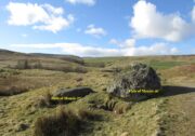
A couple of miles east of Crieff, take the A822 road from the Gilmerton junction towards the Sma’ Glen. After literally 1¾ miles (2.8km)—just 100 yards before the track up to Connachan Farm—you’ll reach a dirt-track on your left that leads into the hills. Go on here and after an easy walk of 400 yards or so, you’ll reach a conspicuous large boulder just by the track-side, on your left. It’s impossible to miss!
Archaeology & History
Immediately adjacent to the Falls of Monzie (7) carving, this petroglyph was located by Paul Hornby on a recent visit to the Falls of Monzie cluster.

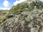
More than halfway up its south-sloping face are two very distinct cup-marks, some two inches across and up to half-inch deep: one near the western-edge and the other closer to the middle of the rock face. You can’t really miss them. They seem to be accompanied by a third about 2 feet further across to the right on its more eastern side. In formation, the three of them form a small raised arc. With the naked eye they’re very easy to make out, but were difficult to photograph due to the daylight and angle of the stone; hence in the photo here, I’ve numerated them.
© Paul Bennett, The Northern Antiquarian
The map could not be loaded. Please contact the site owner.