Settlement: OS Grid Reference – SD 888 237
From Bacup town centre, take the A681 Sharneyford road for about 1½ miles towards Todmorden. At Sharneyford village take the footpath south for about 1 mile to Parrock Farm. At the farm, take the footpath in an easterly direction to Tooter Hill. Upon reaching the hill, head around the southern periphery for about ½-mile, or climb the hill to its height of 430 feet. Here is the former site of a Neolithic or Bronze-Age settlement. From the top of the hill you get fairly spectacular views of the surrounding countryside.
Archaeology & History

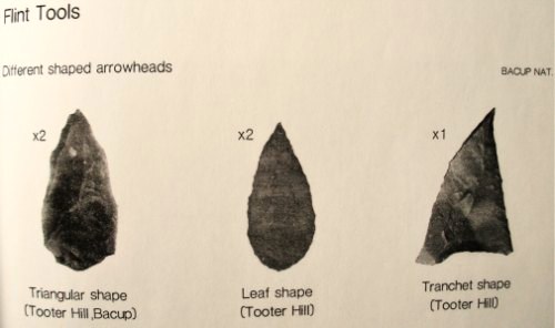
The former (or lost) site of The Tooter Hill prehistoric settlement or enclosure is not marked on any map. It has unfortunately suffered from quarrying on its periphery, but this has long since ceased. There are some small mounds at the southern side of the hill along with traces of earthworks, but I don’t know whether these are part of the former quarry workings. However, a number of artefacts have been excavated from the peat at this site; these include a tanged and barbed arrowhead with serrated edges — probably from the Neolithic period 4,500BC-2,500BC as well as a Bronze-Age arrow-head 2,500BC-700BC, and also a tranchet-shaped arrow-head of unknown date. These artefacts are housed in the N.A.T museum in Bacup town centre. Other finds from Tooter hill on display are some small flint implements such as a flint scraper, flint adze and a flint borer.
References:
- Yates, G.C., “Stone Implements,” Transactions of the Lancashire & Cheshire Antiquarian Society, 5, 320-331.
Copyright © Ray Spencer 2011