‘Standing Stone’: OS Grid Reference – SU 12828 71508
Also Known as:
- OD II (Fowler)
- Parsons Penning Stone
- The Polissoir

We were graciously guided to this spot by local archaeological authority, Pete Glastonbury — which is good, cos otherwise it’d have probably taken us all day to find the damn thing! Best way to get here is out of the Avebury circle, east, up for about a mile up the Herepath or Green Street till you hit the ancient track of the Ridgeway. Turn left and walk up the gentle slope for another 350 yards or so, then note the footpath on your right. Go down the slope for about 150 yards, keeping your eyes peeled for the smooth rock with the slits in it, not far from the Holed Stone!
Archaeology & History
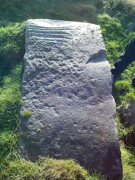
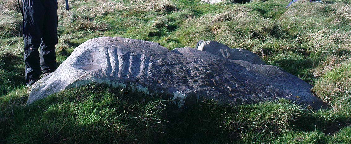
Although classified on the Wiltshire Sites & Monuments Record as an “unclassified feature,” this is one of a number of whetstones (as we call ’em up North) that feature in various settings in and around the Avebury region: literally, a rock used for sharpening axes, daggers and other metallic artifacts. First rediscovered in the spring of 1963 by a Mr Inigo Jones when he was out exploring the many rocks hereby for rare lichens and any more cup-markings like the one at nearby Fyfield Down, the site we see today is merely a long piece of stone with five or six long lines or grooves cut into the top-end, along which the ancient weapons and tools slid and cut into the rock, sharpening them.
It was thought until recently that this was the prime function of this stone; but following excavation work done here by Pete Fowler and his team in 1963, it seems that the stone actually stood upright! Digs were made on three sides of the stone and some earlier disturbance seemed apparent:
“The material appeared to be redeposited on top of an earlier ground surface, inferentially of medieval or earlier date. At the north end of the sarsen bench, the lip of a pit or trench was partly excavated. It showed clearly in plan as a feature dug into the top of an undated surface level with the disturbed top of the clay-with-flints; it was filled with flinty, clayey humus similar to that through which it was cut. In the top of that fill was a heavily weathered sarsen, c 0.6m by 0.45m, and a cluster of smaller, broken sarsen stones. The hole was at least 0.45m deep, its bottom as excavated marked by an increase in the density of flints. The evidence, though incomplete, suggested very strongly that the feature was part of a hole dug to take the pollisoir as an upright stone.” (my italics, Ed)
In the same dig, a medieval coin of King John (1199-1216) and the remains of a medieval horseshoe were found beneath the stone, giving Fowler and his team the notion that the stone had been split and pushed over at this period. Consistent evidence of activity from the neolithic period onwards was expected and found here.
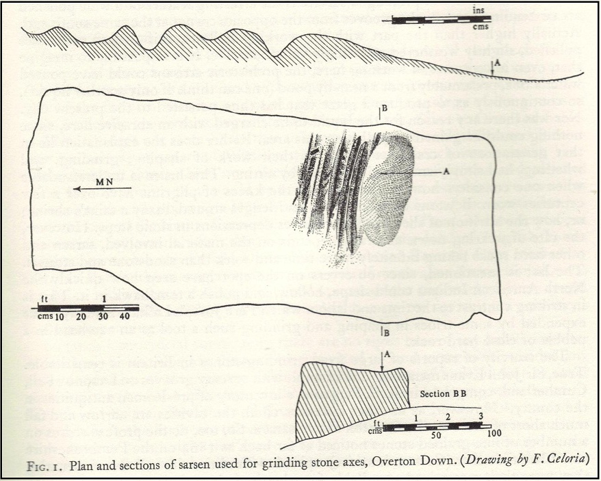
In Lacaille’s (1963) original description of the site, he gave a most accurate description of the dimensions of the stone and its incisions. Highlighting its proximity to a cluster of other stones, as well as being close to a wide ditch, Lacaille’s measurements were thus:
“From 1ft (0.31m) above ground at its south end the regular surface of the sarsen slopes to the grass, its main axis being aligned about 15° west of the true north and south line. In length the stone measures 5ft 6in (1.68m) above the grass, and 2ft 10in (0.86m) in width.
“Closely grouped in the south-eastern corner of the sarsen there are six hollows. In plan the largest and southernmost is of long elliptical shape, 1ft 8in (0.5m) long and 9in (0.23m) at widest and 1in (0.0254m) deep. From its wider end near the eastern long margin there protrudes a short groove. Beside this, and curving slightly inward, there is another groove, 1¼in (0.028m) wide and ½in (0.013m) deep. It is as long as the large basin-like cavity. Next to it there runs one of similar length and width, but of only half the depth. In turn, a third groove, ½in (0.013m) wide, 1ft 8in (0.5m) long, has been worn at right angles to the long edge but to a much deeper hollow than its companions. At 2in (o.051m) to the north a lesser version of the main basin occurs. Like this it measures 1ft 8in (0.5m) in length, but is only 2¼in (0.058m) wide and ¾in (0.016m) deep. Vague in places over its interior length of 10in (0.25m), but attaining a maximum width of 1¼in (0.028m), a last hollowing shows faintly at both ends and nowhere deeper than 1/8in (0.0032m).”


It appears that this fallen standing stone was being used to sharpen knives and axes whilst it stood upright and, in all probability, as a result of this ability would have been possessed of magickal properties to our ancestors. Metalwork was an important province of shamanism and smiths, whose practices were deeply enmeshed in the very creation of mythical cosmologies. Hence, the simple act nowadays of sharpening metal tools onto rocks would not have been a mere profanity to the people who came and used this stone to re-empower their weapons, but would have been entwined within a magickal cosmology. The spirit inherent in this stone would likely have been named and recognised. Today it is forgotten…
It also seems that this standing stone was part of some ancient walling. Aerial views clearly show it along the line of some sort of enclosure that runs down the slope, along the bottom and back up and around. In the same stretch of this enclosure walling we find the Holed Stone a little further down the slope. And holed stones, as any student of folklore and occult history will tell you, have long-established magickal properties of their own…
References:
- Fowler, Peter, Landscape Plotted and Pierced: Landscape History and Local Archaeology in Fyfield and Overton, Wiltshire, Society of Antiquaries: London 2000.
- Grigson, Geoffrey, The Shell Country Alphabet, Michael Joseph: London 1966.
- Lacaille, A.D., ‘Three Grinding Stones,’ in Antiquity Journal, volume 43, 1963.
- Watts, Ken, “Fyfield and Overton Downs, Wiltshire: A Prehistoric and Historic Landscape,” in 3rd Stone, no. 33, January-March 1999.
Links:
© Paul Bennett, The Northern Antiquarian
The map could not be loaded. Please contact the site owner.