Timber Circle / Earthworks: OS Grid Reference – SY 556 917
From Litton Cheney go north up the White Way road until it meets the main A35 crossroad. Go across the road, then get over the fence on your right and onto the rise in the hill. These earthworks, or timber circle remains, are under your feet!
Archaeology & History

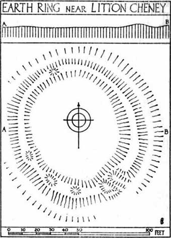
Shown on modern OS-maps as an ‘earthwork’, but ascribed elsewhere as a timber circle, when Stuart & C.M. Piggott visited and surveyed this site in the 1930s, they thought it to be the remains of stone circle. Found on a prominent rise in the landscape with excellent views all round here, the Piggott’s description of the site told:
“It consists of a shallow ditch with internal bank, enclosing a somewhat oval area measuring 75 feet from north to south, and 63 feet from east to west. The ditch, which lies on the southeast, where the ground has been disturbed, does not reach a depth of more than about one foot, while the bank rises nowhere above 2.5 feet. It is possible there was an entrance on the southeast, but the bank is disturbed at this point. On the crest of the bank on the southwest are 3 almost circular depressions, some 6 feet in diameter, and placed 20 feet distant from one another along the circumference of the bank. Another similar depression is on the northeast, while yet another may have existed in the disturbed portion of the bank on the southeast.”
It was these finds which led them to suppose a ring of stones originally surmounted this small hillock, twelve in all.

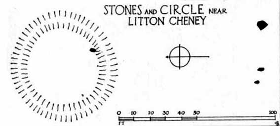
Another site — which they called ‘Litton Cheney 2’ — was found less than 50 yards to the east of here by a Mr W.E.V. Young and the Piggotts. These remains comprised of, “a very shallow and regular ditch surrounding a circular area 47 feet in diameter. A single sarsen lies on the inner lip of the ditch on the southeast” which, they thought, may have been the solitary remains of yet another stone circle. Three other sarsen stones were found 90 feet south of here, but they were unsure whether they related to the circle or not.
Archaeological remains from here dated from 2200-1400 BC and local researcher Peter Knight (1996) thought that the sites ascribed here as megalithic rings to be correct. He also found that tumuli visible some 5 or 6 miles southeast of here, on top of Black Down Hill (where the Hardy Monument’s found), “marks out the winter solstice sunrise.” A dip in the horizon to the northwest, he claims, also marks the summer solstice sunset from here. Knight also mentions how “both Litton Cheney sites lie close to a ley line going to the Nine Stone Circle and beyond.”
References:
- Knight, Peter, Ancient Stones of Dorset, Power: Ferndown 1996.
- Piggott, Stuart & C.M., ‘Stone and Earth Circles in Dorset,’ in Antiquity, June 1939.
© Paul Bennett, The Northern Antiquarian
The map could not be loaded. Please contact the site owner.